Radiotelemetry: Revolution that has revealed the secrets of the Eighties
2020/09/01 Elosegi Irurtia, Migel Mari - Biologoa | Villanua Inglada, Diego - Albaitaria | Campion Ventura, David - Biologoa Iturria: Elhuyar aldizkaria
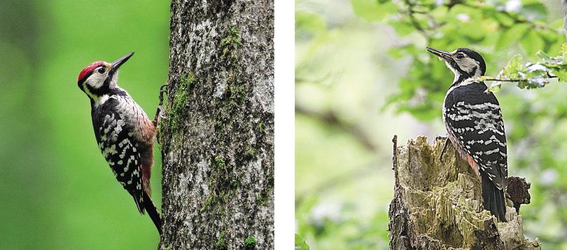
Until now, the question about the movements of this species was almost everything, since at first glance it is difficult to know the nature of the flesh. But things have changed radically with the development of GPS radio telemetry technology.
Special population adult forests
Hepatic pito is a bird that needs mature forests, as one of its main sources of food are insect larvae that pierce the wood. The global distribution is very wide, but in southern Europe it lives in isolated populations. At present, experts discuss whether the subspecies of the Pyrenees and the eight-footed liver lilfordi has become a species in the Mediterranean area. In any case, in our case, this species is in danger of extinction, so its conservation is important.
It inhabits different types of forests throughout the world, but in the Pyrenees it inhabits adult beech. This dependence, however, has its starting point: as the time grows for them to cut forests and the exploitation of forests can endanger the species. Unfortunately, due to the inappropriate forestry work, some territories of lost liver cells are known, so it is essential to establish an adequate management that allows to combine the farms with the conservation of the species.
Unknown species
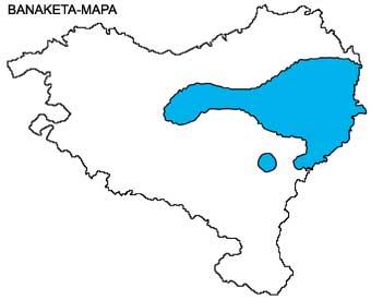
99% of the hepatic bird population of the southern slopes of the Pyrenees is in Navarre, since currently only one couple is known in Aragon (specifically in the area of Zuriza) and there are no specimens outside it. Therefore, Navarre has a special responsibility for the conservation of this species.
However, in order to properly manage the species it is essential to know its ecological needs. Given that according to the bibliography of Sweden and Norway it used a territory of between 50 and 100 hectares, the technicians who managed the species in Navarra thought it would be similar. On many occasions, however, there is a big difference between books and reality, in which it was convenient to investigate.
Until recently, to know the characteristics of the territories in which birds live, in the first place the bird nests were located and their environment was studied, measuring the thickness of the trees, their height, the amount of dead wood and other variables. Based on this, it was concluded that the birds lived in the oldest forests of Navarre, in the largest and thickest trees and in the areas with abundant dead wood, that is, in the ancient forests little affected.
Forest evolution and importance of forestry
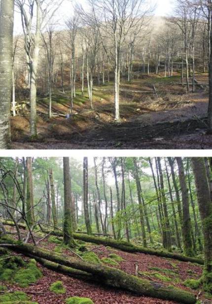
Most of the forests of Navarre have historically been exploited for wood and coal, which has made the hepatic ochre disappear from wide areas and has become rare. Today, however, many forests are spreading that once suffered hard exploitation. After centuries of pressure and decline of the cattle ranch, the forest has recovered large areas lost, for the benefit of the rod and many other species.
At the same time, forests are important renewable resources. They accumulate wood, water, CO2 and a great biodiversity, are a source of income of great importance for forest owners and, in the current context of energy needs and climate emergency, their conservation is essential. Since the key to the conservation of hepatic pines is forest management, it is especially interesting to know the habitat and movements of the ochomiles. How can it be done? What was done with a first direct observation, today the use of modern technologies has been added. Radio telemetry is undoubtedly a revolutionary system.
Radiotelemetry to meet birds
The Navarra Administration, along with other Pyrenean territories, presented itself to a call from the European Poctef and created the HABIOS project, with ERDF funds, with the aim of conserving in 2016 the Pyrenean bioindicator birds. The most important objective of the environmental technicians of Navarra was to learn in the project about the hepatic ochomiles in order to combine their conservation with productive forestry.
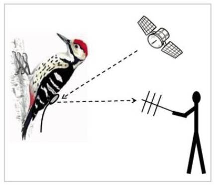
When the project began, there was no technical possibility of installing GPS emitters to the hepatic ochomiles, which were too heavy for them. This bird has a weight of 100 grams and, wisely, a device that does not exceed 4% of the weight of birds can be placed. However, an English company started manufacturing smaller and smaller emitters and got them to be 3.4 grams. After a series of improvements, the emitters can receive about 300 specific locations by GPS and thanks to a special receiver you can recover this data without the need to recapture the bird.
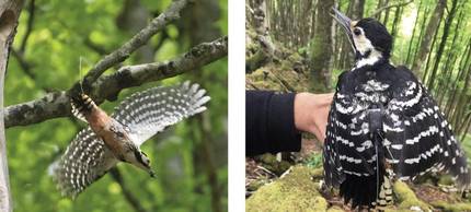
The first obstacle was to catch the birds to mark. The network system used in North America for bat capture was used. For the first time in the world, network tracking was achieved using GPS technology. The information obtained thereafter disadvantages many prejudices.
Surprising results
Thanks to radio telemetry, satellites that circulate around the Earth (the device must receive information from at least four satellites) can triangulate them and determine, through complex mathematical algorithms, the position of the knob marked with an error of between 5 and 25 meters. The location of the bird is determined three times a day and the data is collected in a tank carrying on the back. Subsequently, to collect this data it is enough to approach a kilometer of the bird with the receiver, without disturbing the bird any more. After several months of tracking red birds with GPS, some previously unknown things begin to clear up.
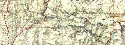
With radiotelemetry, maps full of points are obtained, that is, all those that indicate where the meat has been. The first surprise was to see the large area they use, much more extensive than the territories found in the bibliography. The average area of the territories analyzed in Navarra is 225 hectares, and some of them reach up to 500 hectares. This has allowed us to know that there are fewer bakery territories than the technicians expected. In fact, it has been possible to learn that the territory of a single pair of birds is the territory in which some cases occurred that before receiving the data were considered two different territories.
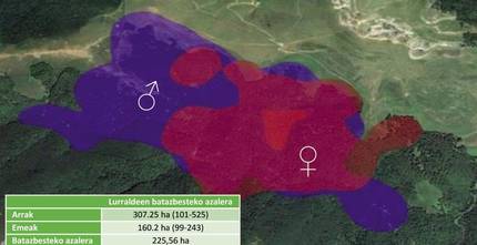
Moreover, males move more than females, and nests in most cases are not in the center of territories. Therefore, habitat measurements made so far were not correct, as they were done in areas where birds were sometimes not used and no other frequently used were studied at all.
In these vast lands, birds use much more sites than others. Various tours of the territory have been carried out for analysis, comparing many points and few (many and few used by birds). The birds have used much more the places where there are dead trees than those that do not have dead trees, because in them they find abundant food.
As has been seen, and as was known, excellent leaks are used, but also very different areas: poor forests of areas with little land, renewed forests of the strain, moist trees hanging, etc. Beech trees are the main habitat of birds, although they also tend to frequent oak trees, larches, hazelnuts, etc. If you have enough dead wood, the meat can be adapted to it. Finally, the analysis of the contiguous territories has allowed us to affirm that at the time of reproduction the birds barely penetrate the territory of the adjacent birds.
Knowing these results, the management was adapted and currently the guidelines used in recent years for the exploitation of beech trees are being reviewed.
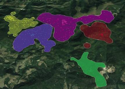
Integration conservation and forest management
Radiotelemetry has changed the vision of the hepatic ochre. It is not, as was thought at first, a species that is limited to the excellent corners of mature forests, but uses a huge territory. The species can live in exploited forests, of course, but with proper management.
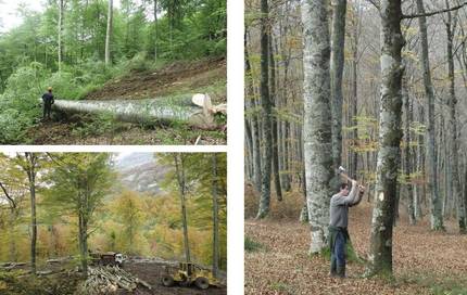
In the classical forestry of Navarre, beech was managed as a regular forest (formed by trees of the same age). Usually the dominated trees were the first to remove them in the entresacas, and in this simplified structure there were very few dead woods. In addition, when it reached 100 years, after the last clearing, the forest was reinforced and all the old trees were cut, eliminating the habitat of the birds for years.
In recent years this situation began to change in some places, driving an irregular forest of greater complexity. However, radiotelemetry has shown that forest management must be done on wider surfaces, as the territory of birds is much wider. All tree species (not only beech) must also be taken into account, as they are also a source of food and habitat for this species. The first tests of this form of management have begun to be carried out, but it will logically take time to adequately understand the consequences of forest work.
Meanwhile, technology continues to improve. In the future they will be smaller and longer lasting radio telemetry instruments, and of course much more can be learned about forest species. All this information will create better tools for the conservation of forest biodiversity and ultimately promote more sustainable forestry.
Bibliography
Thank you: Thanks to the Environment Department of Navarra, the GAN-NIK Group and the Forest Corps of Navarra.
Work presented to the CAF-Elhuyar awards.

Gai honi buruzko eduki gehiago
Elhuyarrek garatutako teknologia


