Marine elephants, helpers of oceanographers
2011/01/23 Aulestiarte Lete, Izaro - Elhuyar Zientziaren Komunikazioa
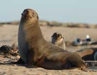
Oceanographers continue to work to get to know the seabed of Antarctica's continental shelf, and it seems that on this road the southern sea elephants are important sources of information. In recent years they collaborate “together” with mammals, animals that have not only proved skillful swimmers, but also proved to be great “spies”.

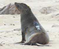
Between 2005 and 2009, biologist Daniel Costa, of the University of California (Santa Cruz), installed 57 marine elephants. It was a procedure within an ecological investigation whose objective was to study the habitat and feeding of the animals of the ocean and how climate change affects them.“We had an interest in knowing where the animals were and what they were doing.”
During the study, in 2008, Wilkins began dismantling the ice bridge linking the ice sheet with Antarctica. Many groups of researchers soon started trying to figure out why this happened, and Costa realized that the data collected through their “labeled” mammals could be of great help. In fact, I knew that the animals were swimming and gathering information in the area.

Well, the receptors attached to the leather of the southern marine elephants measured the sea temperature, salinity and pressure. For a year, the devices that collected these data, whenever mammals went to the bottom of the sea in search of food. And when going to the surface, the information was sent to the database managed through the Argos satellite system.
For four years Costa was dedicated to collecting this information and during that time the sea elephants were submerged tens of a thousand times in the ocean floor. When analyzing the data, the researchers took the result with satisfaction: the map obtained with the seabed or the “image” was much richer and more complete than any other. “Animals that, according to the previous maps, were immersed in the depths that were under the seabed,” explains the biologist.
The extreme climatic conditions in the environment of Antarctica make the cartography of the seabed not a challenge. Traditionally, ships pass through a given area and perform accurate measurements to form a representative map of the ocean bottom. But he is a continent covered with ice and it is very difficult to navigate through icy waters. In this way, the maps surrounding countless areas were based solely on estimates obtained indirectly via satellite.
Discovering “secrets”

When Wilkins began to undo the ice sheet, the oceanographers of Oregon who were dedicated to the study of the underlying waters needed a highly accurate marine background image to understand the marine currents and the trailers under the ice mantle. Costa got in touch with these researchers and began to collaborate to discover the “secrets” that hide the ocean.
The new map they have completed shows that the continental slope, on the edge of the continents, an area inclined between the continental shelf and the abyssal sea bottoms, presents a series of depressions. In these depressions, the warm open ocean water crosses the continental slope and reaches the icy water of the lower part of Wilkins. The researchers have come to the conclusion that the temperate water flow would be directly related to the start of the ice sheet shredding. Several media have released the result of their work.
Researchers say that the information obtained is “really useful” to analyze, for example, how the South Pole Ocean is changing and how those changes affect marine elephants and other animals. “Mammals have allowed us to analyze in advance an ocean bottom that was not accessible to humans.”
Published in 7k

Gai honi buruzko eduki gehiago
Elhuyarrek garatutako teknologia


